| Well Information Table |
|---|
| Common Well ID | DWR20WCB |
| USGS Site Use Information | Unknown |
| USGS Groundwater Use Information | Unknown |
| Data Source(s) | DWR |
| Location Data |
|---|
| Longitude/Latitude (NAD83) | -105.90972900 , 37.18829178 |
| Longitude/Latitude Data Source | DWR Confined |
| DWR Longitude/Latitude (NAD83) | -105.9097290 , 37.18829178 |
| Easting, Northing RGDSS-NAD83 (US ft) | 131374.90 , 70136.76 |
| Elevation and Depth Data |
|---|
| Ground Elevation (ft NAVD88) | 7651.86 |
| Elevation Data Source | DWR data |
| DWR Confined wells (ft NAVD88) | 7651.86 |
| 1/3-Arc Second NED Ground Elevation (ft NAVD88) | 7651.85 |
| 1-Arc Second NED Ground Elevation (ft NAVD88) | 7652.04 |
| SRTM Ground Elevation (ft NAVD88) | 7657.47 |
| Depth to Top of Screen (ft) | 115.0 |
| Depth to Bottom of Screen (ft) | 379.00 |
| Model Layer | 3 |
| Model Layer Source | DWR |
| Depth of Bottom of Layer 1 | 35 |
| Depth of Bottom of Layer 2 | 152 |
| Depth of Bottom of Layer 3 | 362 |
| Depth of Bottom of Layer 4 | 1269 |
| Additional Well Information | NONE |
| Aquifer Information |
|---|
| Aquifer Type | Confined |
| Aquifer Type Source | TD Elevation/Model Layer |
| Water-level Database Information |
|---|
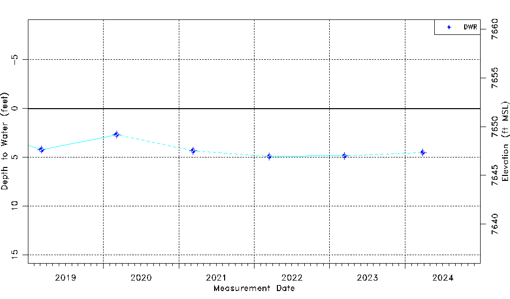
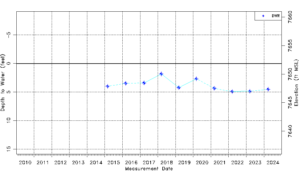
| Water-level Count | 10 |
| Water-level Date Range | 02/27/2015 thru 03/26/2024 |
| Monitored within the last 18 months | No, most recently on 03/26/2024 |
| Depth-to-Water Range (ft) | 1.83 to 4.92 |
| Water Table Elevation Range (ft NAVD88) | 7646.94 to 7650.03 |
| Water-Level-Source:Number-of-Measurements | DWR:10 |